Allied Catawba specializes in scientific and engineering research and development in computer vision (CV), artificial intelligence (AI), machine learning (ML), data visualization, 3D immersion, and Natural Language Processing (NLP).
Our core focus is primarily on advancing transportation solutions, such as crash avoidance, automated infrastructure auditing, geospatial processing, and more.
Across these, our emphasis is on improving both the core tools as well as improving and automated workflow processes and overall performance improvement.
Our expertise covers a range of proven and emerging technologies in both theoretical and applied sciences for government, private industry, and academia.
Computer Vision, Artificial Intelligence, and Machine Learning
Our work leverages innovative work in various imagery-themed use cases and techniques such as.
- ResNet (Residual Neural Network) – an artificial neural network (ANN) that builds on constructs known from “pyramidal” logic.
- Fast R-CNN (Fast Region-based Convolutional Network) - uses searches to find selective regions of interests and passes them to a CNN. The technique then tries to find other areas that might be of similar interest by combining similar pixels and textures into several “rectangular” sample boxes.
- YOLO (You Only Look Once) – overlaps conceptually with the family of CNN techniques and has proven successful for real-time object detection. YOLO involves a single deep CNN that splits the input into a grid of cells and each cell directly predicts a bounding box and object classification.
Focus from these include emphasis on: (1) different ways of knowing; (2) clarifying what structures contain knowledge; (3) estimate how reasoning is performed logically; and (4) why explanations are key to CV/AI/ML. These include:
- Explanation
- Inquiry and Reasoning
- Causal Attribution and Explanations
- Decision Theories
Likewise, the tandem to AI is explaining the AI (aka explainable AI or “XAI”). For that, techniques center on how: (1) they appear to support human reasoning and inquiry (e.g., Bayesian probability, similarity modeling, etc.); and (2) represent explanations with visualization methods and data structures, to include:
- Bayesian Probability
- Similarity Modeling
- Intelligibility Queries
- XAI Elements
- Data Structures
- Visualizations
Mitigating Bias in Artificial Intelligence and Machine Learning
Errors and bias can fundamentally limit AI/ML, and much of our CV work places focus on reducing that. For instance, decision aids can help improve decision making and reduce decision errors and mitigate cognitive bias. Our work explores heuristic biases and how to mitigate them, and through that attempt to improve decision making and its trust. Examples include:
- Mitigating Representativeness Bias
- Mitigating Availability Bias
- Mitigating Anchoring Bias
- Moderating Trust
Other Work Supporting IAVO
Working together with our parent company, IAVO, the following represent representative examples:
- Micasa™ - a system for use with full-motion video (FMV), from multiple UAVs, and to generate in real-time, fully textured scalable 3D models (e.g., buildings, terrain, etc.) from point cloud data. The output offers sufficient accuracy to allow precise measurement, supporting manned/unmannemission command via lightweight 3D use. Feature attribution and target recognition and tracking are also included as part of Micasa.
- HAMM™ - automatically generates accurate, timely, as-built 3D models of building interiors from video collected by handheld or body-mounted devices (e.g., smartphones, body cams, etc.). Once the 3D model is complete, a spatial-analytic as-built ML floor plan is also computed directly from the 3D geometry. Transmission and lightweight use via the “GeoPackage” data exchange standard is part of the Hamm solution, and that helps ensure future alignment with Web use and Cloud processing and exchange.
- AMCON Geo™ - an innovative framework offering tools for automatically combining, via dynamic conflation, multiple intel sources together in a geospatial foundation, helping to increase operational processing throughput. AMCON Geo puts all the data together in an easy to visualize, and easy to distribute, data package suitable for Web-centric use. AMCON Geo translates the content layers into general “foundation data” containers having associated attributes, each of which is suitable for a specific type of data (e.g., raster, vector, point, geographically linked, etc.).


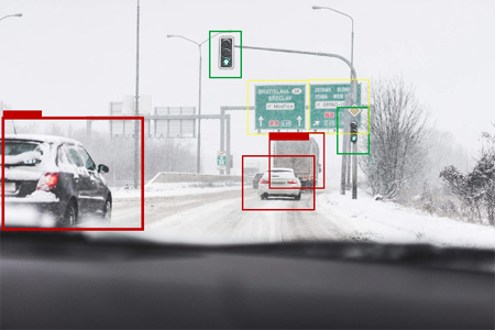
Use of AI and ML for real-time navigation support and accident avoidance
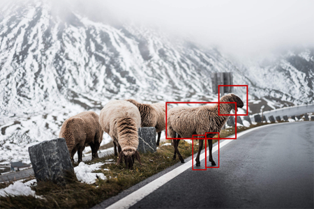
Use of AI and ML for real-time navigation support for wildlife avoidance in lower-light conditions
Research
